Victoria In Her Environment
by Mr A Banerjee

|
|
|
Victoria In Her Environment by Mr A Banerjee
|
 |
|
An edited version of this paper was printed in the Kolkata 1995 Dinner program. This is the FULL version taken from the Victoria School Centenary magazine. johnf
|
|---|
 |
|---|
| Victoria School has weathered more than a century, a century that launched mankind from the Age of Steam to the Space Age; a century of rapid changes reflected in Victoria and Dow Hill environment. Victoria has mellowed and aged and integrated with her environment, loved by generations, not just for her education, but also for her trees, plants, animals and birds, the slopes, flats, dips and paths; stones and soil; for sun, mist, rain and damp; the people, the lines, the town, the district; the grandeur of mountains rising from the plains, bejewelled by twinkling settlements at night. The people here have seen, observed, experienced, recorded and measured their life over the years. This massive collection of data enriched by official records of varying vintage, has built up over more than the last hundred years - a labour of love whose just reward is to be set in perspective for a multi-dimentional picture of Victoria in her environment. This is a stupendous task, and bowing to the limits of time and space, and at the risk of injustice to the past and present staff and students, we have to rest content with what follows: an acquaintance for the unacquainted and for those who know her, at least affectionate recognition and nostalgia ! POLITICAL HISTORY The entire district of Darjeeling was a part of Sikkim in the 18th Century, but in the first decade of the 19th Century the Nepalis conquered and annexed the Terai and the lower hills of the Himalayas. After the Gurkha War in 1817, the British restored the region to Sikkim, though their main Intention was the annexation of this area for military purposes as the key to a pass into Nepal. On February 1, 1835, Sikkimputtee, Rajah of Sikkim gifted the entire hill tract bounded by the rivers Mahanadi and Balason to British India. Although received as a gift, it had to give Sikkim an annual rent of Rs. 3000 from 1841. This was subsequently raised to Rs. 12000 in 1846. Finally, following a successful campaign which started due to the arrest and detention of Dr. D. A. Campbell, IMS (The Superintendent of Darjeeling District) and Dr. H. Hooker (the great Orientalist) by the Sikkimese, the hill tract between the Tista and the Mechi and the entire Terai area which included the previously leased area (including Dow Hill) was permanently annexed to British India in 1850. At present the district has four subdivisions, namely, Darjeeling
(Subdivisional Town: Darjeeling, 2248 m.), Kalimpong (Subdivisional
Town:Kalimpong, 1198 m.), Kurseong (Subdivisional Town:Kurseong,
1483 m.) and
[Kurseong: “This name is a corruption of Karson-rip, the small white orchid, which grows plentifully throughout Kurseong and means the place of the white orchids'. Another suggestion is that it refers to a cane which used to grow there in rich profusion, and which the Lepchas in the ‘Ring-Rong', as they term their own language, call KUR, and SEONG is a corruption of Sheang-a stick " - (O'Malley)] Kurseong is about 640 km. from Calcutta, 48 km. from Siliguri and 32 km. from Darjeeling. In 1880, the Darjeeling Himalayan Railway (the erstwhile 'steam tram') connected Kurseong ith Siliguri, and a year later, the railway was extended to Darjeeling. Previously Kurseong was only connected with Siliguri by the Pankhabari Road which was opened in 1852. Later, the stretch of Hill Cart Road from Kurseong to Darjeeling was opened to traffic in 1864 and after five years, i.e., in 1869 the whole road up to Siliguri was completed. The communication network further improved shortly after the second World War when air-links were established between Calcutta and Bagdogra, thereby making Kurseong easily accessible from Calcutta. LOCATION Victoria School is situated to the East of Kurseong township on the Dow Hill ridge, which radiates from Tiger Hill and comes down on to the plain as a giant serpentine spur. It is also a part of the ridge which culminates in a spot called Chimney to the North East of Victoria School - a saddle at a height of 2196 m. The Dow Hill Road (the erstwhile Old Military Road, laid between 1839 and 1842) ascends fairly steeply from the Railway Station (1483 m), runs along the crest of the ridge and brings us to Dow Hill School overlooking Kurseong township at a distance of 5 km. from the Railway Station. Victoria School lies about 700 m. to the south of Dow Hill School (1830 m) at a height of 1860 m. and is reached by Aranya Sariani passing through a beautiful coniferous plantation. [Chimney: When this was the regular road to Darjeeling before 1864, there was a dak bungalow or an old military camp at the spot, of which only a single chimney now remains. Hence the name.] We get a glorious panorama of the lofty mountains to the North from the Schools. The high peaks like Tonglu (3063 m), Sandakphu (3323 m.) of the Singalila Range to the North-West, Tiger Hill (2615 m), the town of Ghurn (2259 m) situated on a pass to the North can be seen more or less throughout the year. When clear weather prevails, especially from October to March, the majestic snow clad peaks of the Kanchenjungha- Range (about 104 km. away) can be seen through a gap between Ghum and Senchal. At other times they are hidden by envious mists which lift their veil only for a few minutes at rare intervals. [Tonglu: The word means the hill of fir trees. ] [ Sandakphu: The word means the height of the poison plant (Aconite).] Ghum: The word means the bend of the hill. Senchal: The word means the damp misty hill.
Deep shadow cast by the Dhupi frame the Pavilion,
In the distant foreground are the tea-clad slopes of the Lower Himalayas; away to the North, the mighty snow-clad peaks stand out in regal splendour. The snowy peaks visible from East to West are Simvu (6811 m.), Kanchenjunga (8598 m.), Talung (7349 m.), Kabrudome (6600 m.), Kabru (7338 m.), Ratang (6678 m.) and Jannu or Kumbhakarna (7710 m.). Kanchenjunga or Kanchenjungha or Kinchinjunga or Kangchendzonga: The word means the five treasure houses of the snow. (Kang-snow; Chen-great; Dzo-treasures; Nga-five peaks.) The highest peak, which is lit up by the glow of the rising and setting sun, is the treasury of gold; the second peak, which remains in cold grey shade till it is silvered by the rising sun, is the treasury of silver; and the remaining peaks are the treasuries of gems, grain and holy books, which the Tibetans regard as the most valuable of possessions. The Lepchas however, call the mountain Konglo Chu, i.e. the highest curtain of snows". (O'Mally). Kabru: The word means the horn of protection. Jannu: The word means the mountain of massed rainbow: It is regarded as the most awesome high peak in the Himalayan chain and is called the sleeping lion, the Sphinx, the Monster. The charm of Dow Hill lies in the splendid view one gets of these lofty mountains of the North, and also in the spectacular vista afforded by the vast plains in the South. On a bright sunny day, from the neighbouring Forest School, one can see the Tista which gets its name from 'Tri-srota' meaning three currents. It flows through dense forests at the base of the hills till it broadens out towards the distant horizon. The next river further West is the Mahanadi, known as the Mahananda in the plains. It collects water from the Dow Hill ridge forming the turbulent Pagla Jhora and comes down to the plains and joins the Balason-the river of golden sand, about 7.5 km. West of Siliguri. The Balason, after taking its waters from springs in the Ghum ridge near Pulungdung, flows along the Dow Hill ridge near Kurseong and emerges onto the plain at Panighata. Still further to the West flows the Mechi, which demarcates the India - Nepal boundary for some distance. Other important features that meet the eye are the Balason gorge and the Eagle's Crag - a sheer fall of several hundred metres to the Balason valley through which the river describes a gently winding course. Beyond the Eagle's Crag on the Pankhabarl Ridge, one can see the lovely conifers standing like sentinels on the Mirik ridge. It is indeed an experience to be exposed to the wonderful view of the numerous spurs jutting out onto the vast plains of India stretching for thousands of kilometres and gradually merging Into the dim blue of the distant horizon. Mirik : Burnt hill. (Mi-rek means burning of the jungle in Lepcha language.) On a clear, star-studded night, the winding Pankhabari Road with its linear illuminations. the red lights at Constantia-the original site of Victoria and Dow Hill Schools, the main radial arteries of communication of Siliguri - New Jalpaiguri, the settlements of the even further Jogbani in Nepal, the twinkling lights of the scattered settlements on the hills and the twinkling stars in the sky demonstrate the close rapport between man and Nature. SITE The Schools are tentatively bounded by unnamed jhoras in the North and in the South for some distance. Two artificial lines delineate the Eastern and Western boundaries separating the schools from the Khasmahal as well as the forest lands. The area is more or less bounded in the East by the 1890 m. contour line and by the 1800 m. contour line in the West. Thus the configuration is absolutely undulating. The slope is Westward, the gradient fairly steep, and the aspect, in general, is Westerly and Southwesterly. Accordingly, all our school buildings and flats have been constructed following the contours, and it is no wonder that most of the buildings face the West. GEOLOGY Geologically, this area comes within a geo-tectonic belt. Much of the area now presenting some of the most magnificent mountain scenery in the world was under marine conditions over a period of about 600 million years. About 120 million years ago ( Mid-Cretaceous) a plate bearing the Indian subcontinent, broke away from the ancient Gondwanaland and began to drift towards Asia. About 50 million years ago (Mid-Tertiary period, Eocene Epoch) the Indian plate was pushing against the Tibetan plate. As a result of this tremendous lateral pressure, the sediments that floored the intervening Tethys Sea, as well as the base rocks of that geosynclinal basin, buckled up into folds of great heights and formed the Himalayas - abode of snow. So the parent rocks of our area on the lower Himalayas have been sheared, overthrust, invested and therefore present an extremely complicated structure. Our school areas in general, comes within the zone of Darjeeling Gneiss of Archaean age (600 million years ago). It consists of golden and silvery granitiferous Mica Schists, Quartzites and coarse grained Gneiss like, Boitite, Kyanite and Sillimanite Gneiss. The Gneiss is well foliated, crumpled and highly micaceous, and is, composed of white opaque Feldspar Muscovite, Biotite colourless or grey Quartz. Thus in general, the rock is Darjeeling Gneiss impregnated with Mica flakes and carries subordinate bands of Quartzite. It varies in texture from a fine grained to a moderately coarse rock. SOIL Reddish and yellow soils are formed on the Gneisses and Schists of the area owing to the disintegration of the Biotite in the Gneiss. This type of soil is ferruginous, aluminous and siliceous with free Quartz as sand. It is usually poor in Lime, Iron Oxide, Phosphorus, Nitrogen and Magnesia, but fairly rich in Potash, some parts being quite rich in Potassium derived from Muscovites and Feldspar and Gneiss. Brown clayey soil, which is sticky, and generally poor and shallow, also occurs in this area. GROUND WATER Circulation of ground water takes place in the area through joints, fissures, and 'near the surface, through regoliths. Hence the chances of accumulation of a large quantity of water are remote. Moreover, increased run-off due to the steep gradient and unscientific removal of vegetation, and the resultant drying up the aquifers, are turning the perennial 'Kholas' into intermittent 'Jhoras'. CLIMATE The area, though situated within the sub-tropical belt, enjoys a typical mountain type of climate in a monsoon region, in other words, a damp and temperate climate. Temperature decreases more or less at the normal lapse rate of 1 degree C in 165 m. January is the coldest month, with the average temperature around 7.5 degrees C. The mean daily maximum temperature is around 12 C and the mean daily minimum temperature is around 3 C. During the pre-monsoon months a Southerly wind from the Bay of Bengal brings moisture laden air in varying quantities and the impact of this current on the cool North Easterly current gives rise to local storms. The gradual rise of temperature after winter culminates in the month of July, which is the warmest month with an average temperature of about 19.4 C. The mean daily maximum temperature is around 21.6 C and the mean daily minimum temperature is around 17.2 C. The occurrence of dense fog is rather a rule, especially during the dry winter and the wet summer. Hail is fairly common during spring. Frost occurs especially in mid-winter, when the cold North winds prevail. The drawback to such an ideal situation is the excessive rainfall during the monsoon. Here the whimsical monsoon bursts by the first week of June and incessant downpour continues till the first week of October. Relative humidity throughout this period remains very high (over 70 - 75%) and the pressure is around 61.5 cm. Dow Hill, though lower than Darjeeling, receives a much higher rainfall owing to its exposure to the South. And storms and moist winds come up unhindered from the Terai, resulting in heavy showers. Considering the prevailing weather conditions, a year here may be divided into four seasons tentaively: December to February - dry, cold winter; March to May - Spring with some pre-monsoon showers; June to September - warm, wet Summer or the Monsoon season; October to November - Autumn, with some rain till mid October. A summary of the rainfall for the past years (Table no. 1) reveals the alarming fact that rainfall is gradually diminishing, which may be due either deforestation or to the global shifting of the monsoon belt.
|
|---|
|
|---|
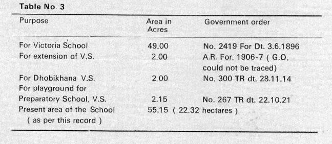
FLORA AND FAUNA The climb from the plains to Victoria School is marked by the unfolding drama of transition from tropical abundance towards the exotics of the Upper Himalayas. .The flora of Dowhill is a combination of the tropical and the alpine. Moss-clothed conifers tower their heads out of the forest gloom, sheltering myriads of epiphytes engorging themselves on the rich, dripping moisture. No Ardenesque serenity, but in triumphant freedom from formal gardens, garden exotics run wild - towering dahlias, rejoicing gladioli, riots of roses. Begonias sprout from moist crevices, lycopodia flow from dense fern brakes, snake plants raise their hoods in thousands and the famous white orchids burst forth in jasmine-scented clusters, while ground orchids spray forth yellow blooms from under the mahonias. The smallest concentration of moist dirt supports its own microcosm. The awe-inspiring gloom of the forest harbours no great water falls, but life itself flows arid leaps in triumphant cascades. Unfortunately, man has, in his eternal selfish, ignorant fashion, ruthlessly exploited this richness, wearing thin this verdant coat, scarred now with landslides. Much of the rich animal life is lost to the area for ever. Yet it still teems with rich fauna. Bands of monkeys still riot in the trees, flying squirrels glide gracefully in the silent gloom and the jackals still serenade the dwindling forests. Kraits and vipers still remind man of his mortality, and leeches remind him that he is not the only one in nature to exploit without return. NATURAL VEGETATION Our area is a part of the Reserve Forest in the Dhobijhora Block and the land was transferred to the P.W.D. in different phases (Table 3) for the construction of Victoria School. All timber and other forest produce on the land are the property of the Forest Department and we have only the right of use.
|
|---|
 |
|---|
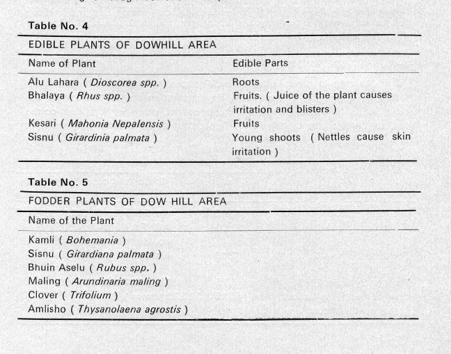
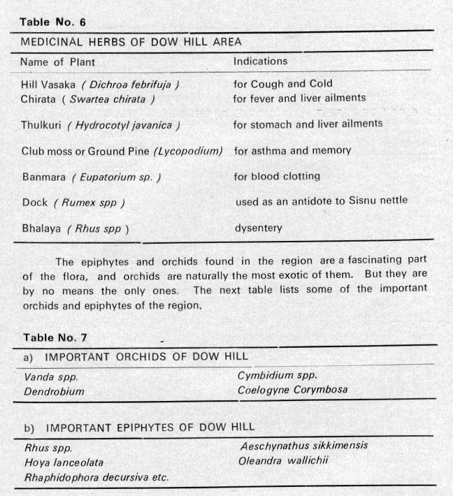
The area comes under the upper hill forest zone ( 1400 m. to 2400 m. ), having wet temperate forests of Champion's 10 B/C type. The poor soil affects the growth and composition of the vegetation greatly. The main species of the upper storey are Pipli, Utis, Katus, Kapasi, Bhadrase, Mouwa, Buk, Champ, Kawla, etc. along with Jhingini, Mahonia, Arkawla, Boketimur (Phaledo), Kharane, Malata, Khankpa, Rhus species, Ghurpis (Leucoseptrum canum), etc. of the second and lower storey. The ground flora consists of Chirata, Vasaka, Asare. Mating, Lycopodium, Chulatro, etc. Among the common climbers are Bal Dhengra (Mucuna macrocarpa), Thotne, Ipomea, Vitis spp., Rosa sericea, Barkuli Lahara Stephania, Paedaria, Gufla (Holboelia), etc. are important. Natural weeds and shrubs and grasses are innumerable, among which, important ones found in our area include Sisnu, Asare, Banmara (Eupatorium spp.). Aselu (Rubus spp.), Rhus spp. The ground flora also include ferns like Gleichenia spp., herbs and weeds like Chirata, Mating, Thulkuri, Lilies, daisies, dahlias, begonias, Cestrum allruntiacum, Colycinus, Potentila, Viola, plants of Acanthacea, Anaphalis spp„ Plantago spp., Rumex spp., Dioscoria (Alu Lahara), Aricaema (Snake plant) spp., Crocus, Anemone spp., Pilea spp. The flora of Dow Hill include a large number of species that are useful to man in various ways - as food, as fodder, as medicine - and the following tables will give a rough idea of their scope.
|
|---|
 |
|---|
 |
|---|
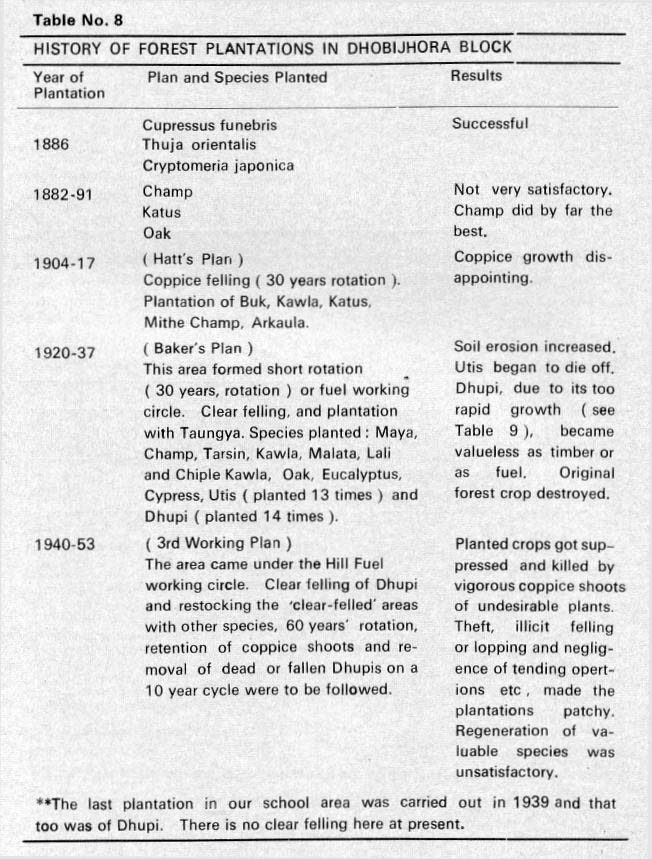
In addition to these are the Mosses, Algae, Fungi and Lichens. Abundant green and blue green algae are met in this area. A beautiful epiphytic alga, •Trentepohlia aurea' covers walls, rocks and tree trunks, and iron bacteria of brick red colour are seen in lumps beside the water courses and where water oozes out from the hills. SILVICULTURE As mentioned earlier, the land on which our school was built was transferred in phases by the Forest Department to the P. W. D. The school thus has a close relation with the forest, which is accentuated by the fact that the trees and timber in the campus are still the property of the Forest Department, mostly planted by it, and also the fact that the Forest School is a close neighbour. It is therefore interesting to take a look at what our friends in that Department have been doing since they started activities in this area.
|
|---|
 |
|---|
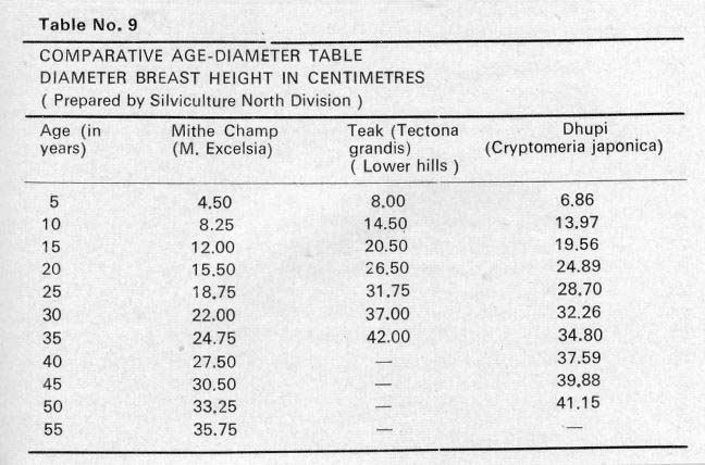
It is interesting here to compare the growth of three species.
|
|---|
 |
|---|
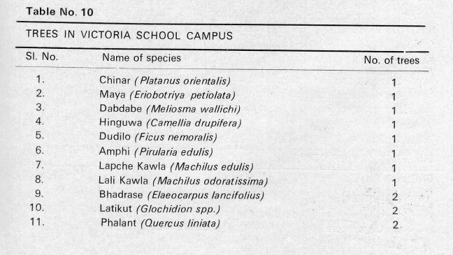
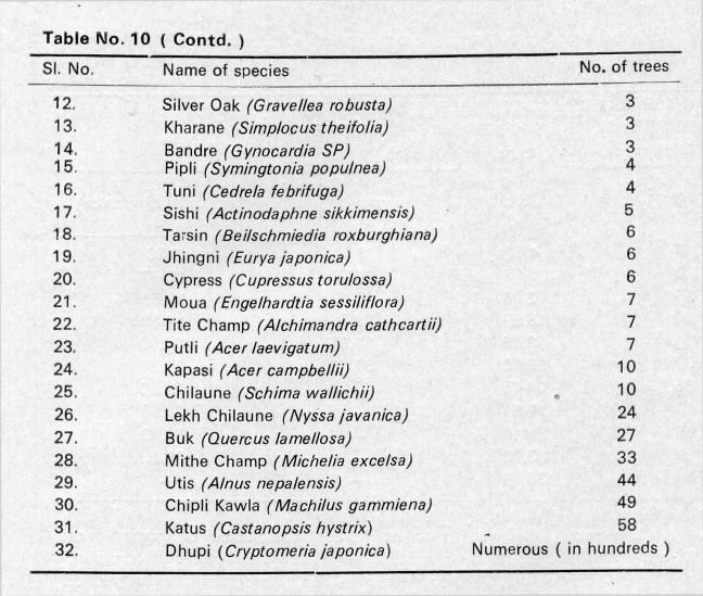
The next table gives us an estimate of the number of existing trees in our school estate. It was prepared during the periods October to November, 1977 and March to April, 1978 under the tree survey programme as a part of the Conservation Plan by Messrs. P. K. Dutta, S. Bhattacharyya, Gam Prasad and myself.
|
|---|
 |
|---|
(Note: Number 1 is the Chinar tree, we know it as the "Calender Tree", by the cricket pavilion. Johnf) Continued |
|---|
 |
|---|
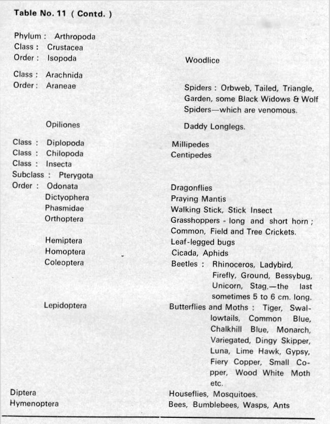
The insects which damage these trees are the twig Borers (Hypsipyla robusta), which frequently attack Tuni, and Bactocera horsfieldii attack Dhupi. The Shoot Borer (Bucklandia polulnea) attacks Pipli and the Champ Bug (Urostylys puncitigera) causes much damage to Champ. A grub, Phassus hepialidae attacks Utis, Dhupi and Champ. FAUNA Beetles, butterflies and insects are our strong point, and an entomologist could be certain of obtaining a new specimen every day. The following table will give a notion of the lower fauna of the area. |
|---|
 |
|
|---|
 |
|---|
VERTEBRATES Amphibians are represented mainly by toads, though the Victoria School Record of 1910 says, "We must not fail to mention that there is a small salamander (Tylotriton vericosus) found in these parts and that salamanders are not found elsewhere in India." It is interesting to note that about three years ago boys of the school collected a few specimens of the Tylotriton species.. Among reptiles, besides several lizards and skinks, there is an abundance of Ophidians, among which we should avoid contact with the Banded Krait (Bungurus fasciatus), Common Krait (Bungurus caeruleus), the Himalayan Krait (Bungurus bungaroide), Russell's Viper (Vipera russellii), Blotched Pit Viper (Trimeresurus monticola). Harmless snakes like the wolf Snake (Lycodon spp), which is sometimes mistaken for the Krait, a reddish brown snake locally known as the Rato Sanp, Black Rock Snake (Kala Sarp), are also observed quite frequently. Another harmless snake False Cobra (Pseudoxenodon macrops) is also seen, though rarely, in this locality. The presence of different mammals is set out below in a comparative table made out with a list of animals compiled during 1906 - 1911.
|
|---|
|
||
|---|---|---|
Other than the above, Ground Shrews (Suncus murinus), Ground Moles or Utani Musa (Tulpa micruro), large Grey Hare (Lepus nigricollis) and the Bandicoot Rat (Bandicota indica) can be seen frequently even now, while the Yellow Bellied Weasel (Mustela Kathiah) is not so common. NOTE : The reader may remark on the absence of birds from the discussion on fauna ; but the omission is intentional, and has been made in order to avoid duplication. An article on the birds of Dow Hill appears elsewhere in this issue. So far we have explored the natural environment in which the school was built, and where it still stands. It is time we studied the actual process of building. So we go on to the next table. |
||
|
||
The Chronological Table above showing when each part of the school was built, may be a poor account of the drama of generations, not only of students, but of the staff as well, that was mutely witnessed by stone and woodwork; but we hope that it at least moves all those who have known and worked amidst these familiar constructions to turn an eye to the past and wonder what the cold mossy stones and the well-worn wood have witnessed-things that they never knew, and yet of which they are a continuum I For Victoria School has marched with many who have died and are past; she has marched with those who have now gone out into the world and maybe still remember the Alma Mater with a bit of affection and pride ; she has marched with those who have taught generations till they have retired with their memories, and with those who still study and teach and relax and work among those same stones, on that same soil, under those same trees. Bibliography 1. Bengal District Gazetteer 1907 - L.S.S.O' Malley. 2. Bengal District Gazetteer 1947 - A. Dash. 3. Geology of Darjeeling and Eastern Duars ' by F.N. Mallet. 4. Geology of India - D.N. Wadia. 5. India and Pakistan - O.H.K. Spate. 6. The Himalayas - 'Y. Shirakawa. 7. Third, Fourth and Fifth Working Plans ( Kurseong Forest Division) - Govt. of West Bengal . 8. The Trees of Northern Bengal including Shrubs, Woody Climbers, Bamboos, Palms. and Tree Ferns. - Cowan and Cowan. 9. The Book of Indian Animals - S.H. Prater 10. Common Indian Snakes - A Field Guide _'R. Whitaker. 11. Encyclopaedia Britannica. 12. Old Records of Victoria School, D.F.O.'s office, W.B.F.S. Office and P.W.D. Office, Kurseong., |
||
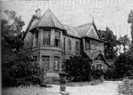 |
The Headmaster's residence | ||
|---|---|---|---|
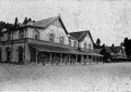 |
Front view of the School building | ||
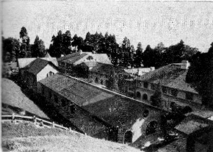 |
Back view of the main School building, in which can be seen a part of the kitchen and store (right foreground), the dining hall next to it, and the R.C. Chapel (present Library) at left. | ||
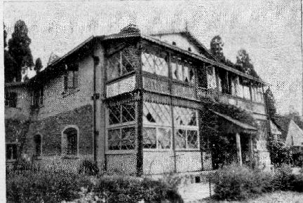 |
The Old Hospital Buiding (now converted to Staff quarters), - the oldest building in the school complex. | ||
|